Follow the Trident and Trees
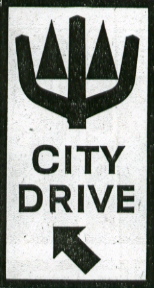
 “Follow the 'Trident and Trees' markers to see Seattle’s many delightful scenic attractions.”
Trouble is, there are hardly any such markers to be found, other than the few I wrote about last month. However, a recent trip to the library answered some of my original questions...
In 1958, the Seattle Engineering Department’s Traffic Division asked the city’s Art Commission for help in mapping a scenic drive around town for both locals and tourists to enjoy. The commission did so, and also urged the Traffic Division to commission a professional artist to design a distinctive marker sign for the project. The Traffic Division chose Robert Mathieson, who described his winning design thusly: “Within a blue Neptune’s trident, representing our surrounding waters, are two simple, elongated green triangles, representing our abundant trees. Water and trees are our great resources. And the driver need read nothing save ‘City Drive’ to understand.”
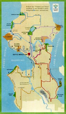
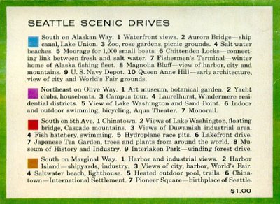
 "City Drive" was changed to “Scenic Drive,” otherwise, that same year the design appeared on 12-by-24-inch route markers installed along 117 miles of city streets. A corresponding color-coded map was created; the one above -- with the "Scenic Drive" image in the upper-right corner -- appeared in a souvenir booklet from the 1962 Seattle World's Fair. It shows four routes, one for each approximate quadrant of the city. Click on the map for a larger view; print it out, along with the descriptions below, and take 'em along on your own self-guided tour!
 Questions remain: How many of these signs are still posted? When were the original 3/8-inch-thick plywood signs replaced with the metal ones we see today? Are missing signs ever replaced anymore, or will they continue to disappear over time? When did the city apparently stop promoting the Scenic Drives?
 I can't find anything on the Seattle Department of Transportation site. I'll drop em a line, and report whatever I find.
0 Comments:
Post a Comment
Links to this post:
Create a Link
<< Home